

Given today’s technological advancements, photogrammetry seems new, but actually, it’s really old. The method of reconstructing measurements is rooted in principles of perspective and projective geometry practiced by artists like Leonardo da Vinci and formalized into a science by German mathematicians in the late 19th century. Yet the photogrammetry field is rapidly evolving through innovations in software and aerial photography.
What Is Photogrammetry?
What Is Photogrammetry?
Photogrammetry involves taking photos of an object or environment from different angles and using these images to generate reliable measurements. By taking photos from various positions and angles, teams can develop three-dimensional coordinates to accurately measure the depth and distance of points in relation to one another.
Visual data can then be gathered to inform drawings, topographical maps, meshes and lifelike 3D models. Advanced software tools have made 3D models more prominent since professionals can leverage these technologies to create digital assets with pixel data gathered from photographs. The technique has become essential for various tasks, including surveying construction sites and flood zones, assessing crop health and exploring fossil sites.
Why Is Photogrammetry Important?
In January of 2021, at a clay mine in Colorado, Alena Iskanderova, a close-range photogrammetrist, made a startling discovery: The tracks of an ancient relative of the crocodile — once preserved for some 100 million years — had been largely erased by erosion.
In the 11 years since the tracksite was first documented, the fossilized footprints left by the animal had lost much of their depth. That the effects of the elements could visibly diminish the tracks in such a short time points not only to their fragility in the face of climate change and other anthropogenic threats, Iskanderova said, but the importance of photogrammetry as a means of preserving the geologic record.
“Sometimes tracks are the only presence of animals in any paleoenvironment. So [photogrammetry] is very important for us to know what kind of animals were there,” Iskanderova told Built In. “The tracks also show us their behavior. Sometimes we can tell, for example, that there was a group of dinosaurs migrating from one point to another.”
After snapping hundreds of overlapping pictures, Iskanderova uses software to patch them together into a single 3D image and create lifelike visualizations, including depth maps showing the geolocated contours of a surface.
Aiding archaeological efforts is only one advantage of photogrammetry, which is also vital for informing engineering projects, documenting crime scenes and guiding space missions, among other use cases.

How Does Photogrammetry Work?
Photogrammetry can be performed using virtually any digital camera that can store images. And in many cases, it relies on the use of drones and other types of unmanned aircraft.
Indeed, the low cost of drones has opened up a range of possibilities — from creating large-scale maps to assessing crop health or planning for emergency relief operations to producing lifelike 3D models of buildings, roadways and flood zones — reshaping the photogrammetry industry.
“I think the big revolution has been with drones,” Tristan Randall, a strategic project executive at the architectural software company Autodesk, told Built In. “In the context of a construction project, for example, where you want to monitor your site conditions, you can purchase drones that cost a couple thousand dollars. So capturing the photogrammetric data has become much, much easier.”
Once programmed, a drone can capture hundreds of photos of a large-scale real-world environment, like a subdivision or city district, in hours.
“It’s literally taking every image and taking all the pixels in each image and looking for another image with at least three matching pixels,” Christopher Kabat, the owner and founder of the drone consultancy ProAerial Media, said. “And it’s going to do that for every single photo that you have.”
Depending on the goals of a project, teams can use drone-based photogrammetry to create photorealistic orthomosaic maps corrected for the curvature of the earth, capture valuable volumetric data — like the amount of soil a building team needs to extract to dig a foundation — or generate interior models for virtual home tours on real estate sites like Zillow. Aerial photogrammetry, though, tends to work best for large-scale projects, not fine architectural details, which are often represented with laser scanning.

Photogrammetry vs. Laser Scanning
Laser scanners can produce high-resolution 3D models and maps, often at a higher resolution than what can be achieved using photogrammetry. Yet they tend to be expensive — sometimes tens of thousands of dollars, according to Randall — and they must be moved into position by human operators to “see” their targets.
“You can imagine a construction site 20 miles from the city,” Randall said. “A pilot has to fly all the way from the airport and then go back. Even inside a building, you have to move the scanning instrument all over the site to capture different viewpoints.”
But drone photogrammetry has its limitations too. Most U.S. airports, Kabat said, are surrounded by LAANC (low altitude authorization and notification capability) grids that require formal FAA airspace authorization.
Drones — more specifically, their cameras — also have trouble seeing through foliage. Kabat’s company operates in the desert landscape of southern Nevada and areas of Arizona and Utah, where photogrammetry works well.
Building edges can also be problematic. Unlike laser scanners, which measure distances as a function of the time it takes light beams to reflect off a target and return to their source, photogrammetry uses pixel matching to approximate distance.
Types of Photogrammetry
There are two main types of photogrammetry that professionals employ when seeking to capture high-quality images of objects and landscapes — aerial and terrestrial.
Aerial Photogrammetry
Aerial photogrammetry involves taking photos with a camera attached to a drone or other type of aircraft. When the aircraft is in flight, the camera is pointed toward the ground and takes overlapping images of the same landscape or area from different angles. A stereo plotter can then calculate elevations by analyzing multiple photos of the same point.
Terrestrial Photogrammetry
Terrestrial photogrammetry is the practice of taking photos with a ground-based camera, either handheld or attached to a support system like a tripod. Teams often use a theodolite to capture high-resolution images on the ground, recording the coordinates of the camera to keep track of its positions. Algorithms can analyze these images to generate three-dimensional data, and then software processes this data to create accurate 3D models and measurements.
Uses of Photogrammetry
Today, photogrammetry is used in commercial applications as diverse as public safety, construction, civil engineering, automotive manufacturing, agriculture and military reconnaissance. And a growing number of use cases has been a boon for the software companies that provide 3D modeling and post-production tools.
Photogrammetry Applications
- Construction
- Documentation and Preservation Efforts
- Civil Engineering
- Archaeology
- Real Estate
- Renewable Energy
- Space Exploration
- Forensics
Advancements in the field have turned photogrammetry into an efficient, cost-effective method for collecting accurate data. In addition, drone technology has allowed teams to capture images in areas that were previously inaccessible. Industries have come to realize the benefits of photogrammetry, adopting it as their main method for gathering visual information.
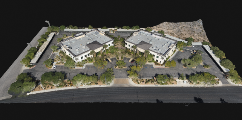
Photogrammetry in Construction
Over the past decade, aerial photogrammetry has radically transformed the construction industry. Instead of hiring a survey team to spend weeks photographing a site with GPS-synced tripods, developers can send a drone into the air to capture site conditions in hours, often at a much lower cost, said Ryan Sweeney, a sales manager at the Denver office of the photogrammetry company PIX4D.
Drones are good at capturing high-resolution photographs, in part because they fly so low compared to human-piloted planes. Drones can also capture a site from multiple vantages and reach places that might otherwise be dangerous for humans to be — like hazardous chemical sites.
In addition to knitting the photos together, software modeling tools or photogrammetry platforms align geotagged pixels against cartesian coordinates ground sampled locally or imported from networked GPS data. Because these renderings are accurate to within inches, architects and engineers can use them to update working “as-built” models so they reflect on-the-ground conditions.
Meanwhile, construction managers can use the 3D models to keep tabs on large-scale development projects, while working remotely.

Photogrammetry in Documentation and Preservation Efforts
During his off-hours, Kabat traces the history of remote stretches of the American southwest with drones and handheld cameras, capturing artifacts in ghost towns and abandoned mines near Las Vegas, and Native American petroglyphs he finds along the Old Spanish National Historic Trail running from Santa Fe, New Mexico, to Los Angeles.
Though the scale of the project is different, it’s not so far removed from what Iskanderova is doing at a more granular level with dinosaur tracks — reconstructing the fragile outlines of an environment with photogrammetry to document its existence and, hopefully, preserve it for posterity.
Photogrammetry in Civil Engineering
Engineers can employ photogrammetry to gather in-depth details about properties and structures, as well as information on surrounding buildings, nearby trees and natural structures and any potential risks like damage to an existing structure. Weighing these factors, civil engineers can plan their projects accordingly and take proactive measures to avoid mistakes or issues that could lead them to redo a project, greatly reducing time to completion and costs in the long run.
Photogrammetry in Archaeology
The ability to create multiple detailed images of an object has made photogrammetry a staple in archaeology. Archaeologists apply the technique to extract details that photography can’t capture, such as the features of individual stones within a structure, the unique details of decaying objects and the bone structures of fossils.
Teams can even go a step further, using photogrammetry to reconstruct 3D models of incomplete objects or artifacts. This brings past structures and living beings back to life in a way, acting as a crucial tool for filling in holes in the archaeological record.
Photogrammetry in Real Estate
Real estate companies have adopted photogrammetry’s 3D modeling capabilities to develop fly-through videos and physical 3D models that allow clients to get a detailed overview of a property. In addition, real estate businesses can also combine photogrammetry and virtual reality to conduct virtual tours of properties and their interiors. This technique is useful both to clients who want to learn more about a property and to architects planning real estate projects.
Photogrammetry in Renewable Energy
Even the renewable energy sector has found a way to make photogrammetry work to its advantage. Organizations develop holistic models of landscapes by taking images with drones. Teams can then gauge what kind of impact wind turbines and other structures would have on nearby communities and the surrounding environment.
In the case of solar energy, renewable energy companies can gather 3D data from drones or unmanned aerial craft to determine the potential for adding solar panels to the roof of a building. This data reveals the angle of the roof, objects like trees that shade the roof and other variables that can influence whether a company moves forward with a solar panel project or not.
Photogrammetry in Space Exploration
Photogrammetry aids space exploration in various ways. Before liftoff, NASA can use the technique to gauge whether a rocket’s boosters are properly aligned. And space teams can rely on photogrammetry to help them spot and assess damages to a spacecraft.
Complementing AR and VR with photogrammetry, space teams can attach cameras to rovers and create 3D models of terrains on the moon and Mars. This way, researchers can better interact with the digital representations of different surfaces and plan for future missions based on the 3D data of landscapes they have at their disposal.
Photogrammetry in Forensics
The ability of photogrammetry to produce 3D models makes it ideal for reconstructing crime and accident scenes. With data gleaned from these models, forensics teams can determine variables like a suspect’s height, a car’s skid marks and the trajectory of a bullet. Having a digital copy of a crime scene also allows detectives to revisit this same scene months down the road, making it easier to spot new clues and details that were missed the first time around.
Photogrammetry Software
From free programs to pricier options, here are a few examples of popular photogrammetry software that professionals and casual users have come to prefer.
Meshroom
Meshroom is a free program that is offered through AliceVision and operates on Windows and Linux systems. The software is designed to be intuitive to users of all levels, relying on various images of an object to calculate measurements and create a mesh. Users can then alter specific nodes, adjusting and retexturing 3D models to their liking.
The result is a customized experience that allows users to make the software their own. For those who want to work on more challenging projects, Meshroom can also process panorama images. This software may be free, but it still remains helpful as beginners expand their skill sets and start to branch out into different areas of photogrammetry.
ELCOVISION 10
ELCOVISION 10 debuted in 1986, earning its title as the first photogrammetry system for PCs. The program has taken major strides since its inception. In 2005, ELCOVISION 10 featured the ability to automatically orient freehand images. The software has most recently showcased automatic high-density point clouds. This latest feature means ELCOVISION 10 can produce images with stunning accuracy, rivaling that of laser technology.
The software only runs on Windows and works for both aerial and on-ground photogrammetry projects. Those looking to get the most out of this program should research which version of ELCOVISION is ideal for their needs. Demo versions of the software are available upon request, and the ELCOVISION team can always address questions about product features and costs.
PIX4Dmapper
A more advanced option on the market for professionals is the PIX4Dmapper tool. This software inputs data from multiple images taken with a camera or drone, converting this data into detailed 3D models and digital maps. Users can also leverage the rayCloud tool to make adjustments to their models, refining their reconstructions to represent the original images as close as possible.
PIX4Dmapper is created with professionals in mind, so it is on the more expensive side. However, it does provide plenty of flexibility, working well with macOS, iOS, Android and Windows formats. Drone enthusiasts will appreciate PIX4Dcapture, which is a free mobile app that allows users to control drones and take various pictures for photogrammetry purposes.
History of Photogrammetry
Photogrammetry can be traced back to the 1490s when Leonardo da Vinci established the principles of perspective and projective geometry. In the mid-1800s, French inventor Aimé Laussedat used these principles to develop terrestrial photogrammetry to produce architectural surveys. The invention of the airplane in the early 1900s made aerial photogrammetry possible, solidifying photogrammetry as a key tool for gathering military intelligence during the First and Second World Wars.
The rise of the space race expanded the reach of photogrammetry, making it essential for capturing satellite images. In the 1960s, photogrammetry was also combined with computer vision to help with extracting 3D data from 2D images. This would spark the development of online mapping platforms in the early 2000s, culminating in photogrammetry’s ability to convert 2D images into 3D models.
Future of Photogrammetry
Supplementing photogrammetry with AI and machine learning capabilities broadens the possibilities for collecting 3D data from photos. Drones equipped with machine learning and neural networks can fly around an object, capture high-resolution images and recreate a 3D model of an object — all within a matter of seconds.
As a result, photogrammetry software and tools are finding different ways to integrate artificial intelligence and machine learning. For example, Pix4D employs AI and ML algorithms to mark the coordinates of specific points, single out objects within a 3D landscape and enhance images by recognizing walls, floors and other interior elements.
These developments reduce the time and energy teams often expend when producing and analyzing 3D models, making it easier than ever to glean high-quality 3D models and images from just a few 2D photos.
Frequently Asked Questions
What is photogrammetry used for?
Photogrammetry generates 3D maps of landscapes and objects, which can inform construction workers on how to move forward with projects, aid archaeologists in finding and preserving artifacts and enable forensics teams to analyze crime and accident scenes, among other uses.
Is photogrammetry still relevant?
While it is a centuries-old practice, photogrammetry is still relevant today. Advances in AI and machine learning have made it easier to produce high-quality 3D models in a matter of seconds, resulting in far more powerful photogrammetry tools.
Is photogrammetry better than 3D scanning?
Photogrammetry excels in capturing the color and texture of objects and landscapes while 3D scanning can depict finer details with more accuracy. For the best results, it helps to combine photogrammetry and 3D scanning, achieving a balance of accuracy and texture.


