About Urban Sky:
Urban Sky is a venture-backed aerospace startup that pioneers utilization of the stratosphere and reimagines the way humans view and analyze the earth. We design, build, operate, and sell stratospheric balloon systems, and the data we collect supports a wide range of applications, from real-time wildfire monitoring to urban mapping. Our technology is also employed by government customers including the Department of Defense (DoD), NASA, and others. Urban Sky sends flight vehicles to the stratosphere on a weekly basis.
Our team consists of engineers, makers, developers, and doers who believe in the power of human potential when passion meets utility within a small, supportive team. At Urban Sky we strive to create a team culture grounded in candor, inclusion, respect and empowerment.
We aim to build the next chapter of stratospheric history in Denver and are seeking self-starting, open-minded, and hard-working team members.
About The Role:
Urban Sky is seeking an experienced Remote Sensing Data Scientist to lead our NASA ROSES-funded "Hot Spot" project, a cutting-edge 3-year fire sensing program leveraging our stratospheric balloon platforms for wildfire detection and monitoring. This role combines deep technical expertise in remote sensing, algorithm development, and data analysis with program leadership responsibilities.
As the primary technical and programmatic lead for Hot Spot, you will own the end-to-end development of Land Surface Temperature (LST) data products—from algorithm design and radiative transfer modeling through calibration, validation, and operational delivery. You will build and maintain data quality control pipelines, develop production-quality software, and translate instrument performance characteristics into robust retrieval algorithms. You will also manage the program schedule, maintain the customer relationship with NASA, and ensure successful execution of all project milestones. This position offers a unique opportunity to shape the future of stratospheric remote sensing while building relationships that will extend to other government agencies including the Air Force and Army.
This is not a role for those seeking a well-trodden path—our work involves solving problems with no clear precedent, designing novel solutions, and iterating rapidly in ambiguous and fast-paced environments. You should be comfortable taking on big ambiguous projects at the forefront of remote sensing, data science, and earth observation. In this role you will have the autonomy to innovate at the cutting edge of stratospheric sensing technology.
Key Responsibilities:
- Lead the NASA Hot Spot program as primary technical and programmatic owner, managing schedule, deliverables, and customer relationships
- Lead algorithm development, calibration, and validation for Land Surface Temperature (LST) data products from thermal infrared (TIR) instruments, including uncertainty estimation and performance characterization
- Implement atmospheric correction and radiative transfer modeling to support LST and secondary geophysical products; assess sensitivities to atmospheric state, surface emissivity, and instrument characteristics
- Design, implement, and own the data quality control (QC) and validation pipeline for all data products, including defining quality metrics, thresholds, automated checks, monitoring, and anomaly detection
- Maintain and extend the data processing codebase for operational delivery of scientific data products, emphasizing scalable workflows, reproducibility, automated testing, and clear documentation
- Support optical and system-level modeling to inform both hardware development and data processing; perform optical performance analysis (e.g., MTF, SNR, stray light, distortion) using tools such as Zemax OpticStudio, Code V, or FRED
- Translate instrument performance and optical effects into algorithm assumptions, correction strategies, and uncertainty models; collaborate with hardware teams on payload design, integration, testing, and performance trades
- Support the design, development, testing, and calibration of high-performance EO payloads for imaging
- Support mission design, trade studies, and requirement definition through data-driven analysis; work closely with instrument engineers and end users to ensure data products meet operational needs
- Document and communicate results via technical reports, peer-reviewed publications, and presentations at internal forums and international conferences
Qualifications:
- Bachelor’s or Master’s degree in a quantitative field (e.g., Computer Science, Statistics, Mathematics, Physics, Engineering)
- 5+ years of experience in remote sensing, algorithm development, or related data science/engineering roles
- Strong background in thermal infrared (TIR) sensing, Land Surface Temperature retrieval, and radiative transfer modeling
- Proficiency in Python for production-quality algorithm development and data processing; C++ experience desirable
- Experience building scalable data pipelines with emphasis on reproducibility, automated testing, and operational delivery
- Strong understanding of calibration and validation methodologies for remote sensing instruments and derived data products
- Experience with optical modeling tools (Zemax OpticStudio, Code V, FRED, or similar) and ability to translate instrument performance into algorithm design
- Demonstrated experience managing technical programs or projects, preferably government contracts
- Excellent written and verbal communication skills for technical documentation, publications, and customer engagement
Nice-to-Haves/Preferred Skills
- Experience with NASA ROSES or other NASA research programs
- Background in wildfire detection, land surface temperature retrieval, or related earth science applications
- Experience with atmospheric correction algorithms and sensitivity analysis
- Experience building data QC systems including monitoring, anomaly detection, and reporting tools
- Experience working with DoD customers (Air Force, Army, or other branches)
- Familiarity with stratospheric or airborne remote sensing platforms
- Track record of peer-reviewed publications in remote sensing or related fields
Requirements:
- Must be US Citizen or Permanent Resident
- Must be located near Denver, CO or willing to relocate to Denver, CO
- Our office is at 4800 Race St. In Denver, CO and this role is on-site
Benefits:
- Salary $120,000 - $170,000 per year
- Stock Options
- Medical, Vision and Dental
- Unlimited Vacation Days
- Cell Phone Bill Stipend
Urban Sky is required to post this salary range per Colorado law. Your salary will be determined based on your abilities and experience.
We expect all team members to actively leverage and continuously adapt to emerging AI tools as a core part of their daily workflow. Proficiency with job-relevant modern AI tools (e.g., ChatGPT, Claude, GitHub Copilot) is expected and integral to success in this role.
NOTE: Research suggests that women and BIPOC individuals may self-select out of opportunities if they don’t meet 100% of the job requirements. We encourage anyone who believes that they have the skills and the passion necessary to succeed here to apply for this role.
This position may require the candidate to deal with commodities, software, technology, defense articles, and/or technical data which are subject to the Export Administration Regulations and/or the International Traffic in Arms Regulations. Additional information may be requested so as to determine whether export authorization is required from the Bureau of Industry and Security and/or the Directorate of Defense Trade Controls. If authorization is required, employment will be contingent upon the Company successfully obtaining such authorization from the relevant government agency.
Urban Sky is an equal opportunity employer, and we value diversity. All employment is decided on the basis of qualifications, merit, and business need.
Top Skills
What We Do
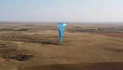
Urban Sky's novel invention, the high-altitude Microballoon™, leverages advances in component miniaturization and first-of-its-kind material re-usability to drastically reduce the cost of high-resolution remote sensing over broad, targeted areas, leading to more impactful data over more areas than ever before.
The Microballoon™ is the first ever reusable stratospheric balloon. It's also the first ever precisely placeable remote sensing balloon. The Microballoon™ has a unique ability to image specific areas at desired times, never before possible with stratospheric balloons. This capability is made possible by coupling advanced balloon design with a very small form factor, enabling launch from virtually anywhere at any time with minimal personnel and equipment required. The Microballoon is also zero-emission, making it the most sustainable way to image Planet Earth.
Remote sensing from the stratosphere combines many of the benefits of both space-based assets and lower altitude airborne vehicles. That means remote sensing data can be collected from the Stratosphere over vast areas, with aerial quality-resolution, at the lowest possible cost. This unique combination of advantages will finally unlock the full commercial usefulness of the Stratosphere.
Why Work With Us
Our team consists of engineers, makers, developers, and doers who believe in the power of human potential when passion meets utility within a small, supportive team. At Urban Sky we are aiming to make stratospheric history in Denver and strive to create a team culture grounded in candor, inclusion, respect and empowerment.
Gallery

_0.png)